Area 1 – Climping* Beach to Lyminster
Page Contents
Introduction
This Area considers the cable route between the ‘landfall’ at Climping Beach and Lyminster. It includes an alternative cable route (ACR), two modified routes (MRs), two new trenchless crossings (TCs) and two alternative accesses (AAs). They are all referenced on the following pages using the abbreviations here.
Our Environmental Assessment of Climping Beach to Lyminster
On the following pages you can read about our preliminary assessment of proposed changes in Area 1. We don’t believe that introducing these changes is likely to change the overall conclusions of our PEIR from summer 2021. You can read more about our consideration of these potential changes in our PEIR SIR at www.rampion2.com/consultations-2021. Just look for the relevant ACR, MR, AA or TC reference.
We’ve split this Area into 3 smaller Areas 1a to 1c. You can use the map below to figure out where you are most interested in and find out more on the following pages

Area 1a: Climping Beach to Ferry Road
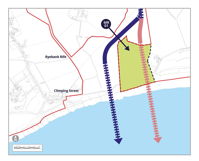
Modified Route MR-01
We’ve listened to concerns about potential coastal erosion and flood risk. This extra area just north of Climping beach would give us greater flexibility on where to drill under MR-01 and the beach. The drilling compound would still be in the north in an area we consulted on last year, or in the very north of MR-01.
We might also need to store soil temporarily in the northern part of MR-01.
We wouldn’t need any above ground works in the southern part of MR-01, nor any additional accesses. However we might need a drilling compound in the northern part of MR-01.
We also need to allow the potential for our drilling to start in a small area just north of MR-01, that we previously only proposed for soil storage. If you want to see this exact area then have a look at Sheet 1 of our Works Plans at https://rampion2.com/wp-content/uploads/2022/10/42285-WOOD-PE-ON-PN-MD-0004-Rev081_A3.pdf
Potential Environmental Impacts
MR-01 would be closer to residences to the east and the Littlehampton Golf Club course. It would also pass under the Climping Beach Site of Special Scientific Interest (SSSI) and a belt of woodland.
These receptors have been identified in our PEIR SIR as either new, or with the potential for a change, in relation to
landscape and visual, ecology and nature conservation effects.
Tell us what you think. Do you have other things you want to highlight to us?
Area 1b: Ferry Road and the A259
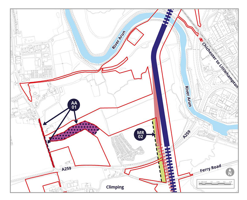
Alternative Access AA-01
This new potential access is proposed to link a construction compound more directly to where the cables are buried. AA-01 includes 90m of temporary works to create better visibility for construction vehicles at Church Lane.
Modified Route MR-02
North of Ferry Road we propose widening the cable corridor by 50m into MR-02. This responds to potential overlap with the West Bank mixed-use development area, but also tries to keep distant from the Climping Park (park home estate) and a historic landfill area.
Potential Environmental Impacts
MR-02 would be closer to Climping Park and next to a historic landfill site. The main area of AA-01 is in an agricultural field, whilst the narrower parts are to create better visibility by widening the existing road. These receptors have been identified in our PEIR SIR as either new, or with the potential for a change, in relation to landscape and visual, ground conditions, ecology and nature conservation effects.
Tell us what you think. Do you have other things you want to highlight to us?
Area 1c: Crossing the tracks at Arundel Junction

Alternative Cable Route ACR01
On the approach to the more northerly railway crossing we have identified the 750m long ACR-01, which is a separate alternative to our existing cable corridor and runs parallel to the railway line for an open trench section between two trenchless crossings. We are including ACR-01 to explore whether we can avoid archaeological finds, which we are still investigating but are more likely to lie on our original route to the east.
Trenchless Crossings TC-01 & TC-02
ACR-01 requires two new trenchless crossings to access the western side of the railway line when leaving and rejoining the existing cable corridor.
TC-01 and TC-02 would take the cables under the railway lines to Worthing and Arundel, and the Black Ditch.
Alternative Accesses AA-02 and AA-03
AA-02 is an existing private road, therefore we need to include it in our revised boundary to ensure access.
AA-03 is proposed to allow temporary construction and permanent operational access to ACR-01. This includes equipment to construct the two trenchless crossings under the railway lines. AA-03 would use an existing private crossing of the railway line and then run parallel to the railway line.