Area 4 – Lyminster to Sullington Hill (Eastern Route)
Page Contents
Introduction
This Area considers just one Longer Alternative Cable Route (LACR-01) from Crossbush to Sullington Hill, and its associated accesses. We have identified this LACR and another one to its west as Longer routes, since they go a long way from our original route.
We refer to this route as LACR 1. However, you can see from the map on the next page that it splits into two further options as it heads north. In our environmental documents we have referred to the southern section as LACR 1a, the north western section as LACR1b and the north eastern section as LACR 1c.
Our Environmental Assessment of the “eastern route” from Lyminster to Sullington Hill
On the following pages you can read about our preliminary assessment of LACR-01 in Area 4. We believe that effects presented in our PEIR from summer 2021 will change for landscape and visual, socio economics and water environment as a result of introducing this route.

Area 4a: Our new route LACR-01a

Longer Alternative Cable Route LACR-01a
On the following pages you can read about the first part of our Longer Alternative Cable Route LACR-01. Our LACR-01 would split in two to take two potential routes when it gets much further north. If LACR-01 is ultimately chosen over other routes that we are considering, we would only need one of these two potential routes. We’ve called the southern part of route LACR-01, before it splits into two routes much further north, LACR-01a.
LACR-01a starts by leaving from an Alternative Cable Route ACR-02 which we are also consulting on. You can read about ACR-02 in the Area 2 part of this Consultation Booklet. This means that if we chose LACR-01 for our final cable route, then would also need to use the majority of ACR-02. Therefore, in our consideration of the environmental effects of LACR-01, we have also considered the effect of the relevant part of ACR-02. After leaving ACR-02, route LACR01a, would firstly run eastwards across agricultural land where it is connected via Alternative Accesses that you can read about on the next page. As it heads east it would cross Poling Street in open trench, where two operational accesses would be created directly into the footprint of LACR-01a.
Area 4a: Our new route LACR-01a

Alternative Accesses AA-16 & AA-17
In addition to construction and operational accesses being created from the new Lyminster Bypass further west, we would also require AA-16 and AA-17 through the Vinery Industrial Estate. AA-16 would be for temporary construction access, whilst AA-17 would start at the same point but run east of Lillian Terrace to become a permanent access.
Alternative Access AA-18
AA-18 would be used for construction or operational access at the Decoy Lane crossing point. AA-18 would be via an existing entrance from Decoy Lane, although this may need some improvement so that we could use it.
Trenchless Crossing TC-22
TC-22 would allow us to cross an existing tree line and ditch without disturbing them.
Trenchless Crossing TC-23
TC-23 would allow us to cross Decoy Lane without disrupting access or uses there.
Trenchless Crossing TC-24
Area 4a: Our new route LACR-01a

Longer Alterative Cable Route LACR-01a
After crossing Decoy Lane, the cable route would start to turn northeast and cross the A27 Arundel Road. From here it would continue northwards across agricultural land north of Hammerpot, avoiding areas of Ancient Woodland. Entry to the cable route north of the A27 is proposed via Arundel Road at Hammerpot, whilst exit would be back onto the A27 at the junction with Angmering Park. Both of these entry / exist are within the LCR-01a boundary, however a separate accesses would also be created at AA-19 and AA-20.
Area 4a: Our new route LACR-01a
Alternative Access AA-19, AA-20 & AA21
Trenchless Crossing TC-25
TC-25 would allow us to cross a mature tree line north of Hammerpot without affecting it.
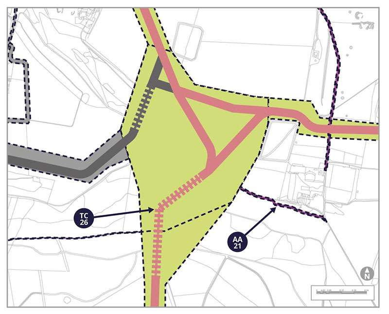
Trenchless Crossing TC-26
TC-26 is proposed so that we can take our cable route down the steep wooded slope at Michelgrove and leave the trees unaffected. This trenchless crossing would allow us to get to an existing clearance in the woodland, which we can sue existing tracks to access. This means that we would minimise the effect we would have on this area.
Potential Environmental Impacts
LACR-01a introduces the potential for new effects on the environment, which are assessed in our PEIR SIR.
During the construction period, some bridleways and footpaths will need to be diverted for short distances or temporarily interrupted for a limited duration.
The route passes through the South Downs National Park, and six Landscape Character Areas. The route also passes through seven hedges or treebelts, which we will replant afterwards.
This alternate route and accesses will introduce new potential receptors into proximity in respect of air quality. Different homes nearby would also have the potential to be affected by noise and vibration caused by construction or construction traffic. This route may affect individual roads differently from our previous assessment in a limited way.
Most of this alternative cable route runs through arable farmland bordered by hedgerow, which is similar to the landscape already assessed. Areas of Ancient Woodland would be drilled under, and there is a small group of trees (not ancient woodland) that may need to be removed.
We do not think that this alternate route changes our assessment of soils and agriculture. We have not identified any new sources of ground contamination within this corridor. The work area would come close to Swillage Land Landfill and the Vinery Industrial Estate, but we consider the distance from the landfill site, and our usual construction measures will prevent the likelihood of contamination.
There are no standing historic features along the route of the proposed cable, but there is potential for buried archaeology from all periods, including Bronze Age and Roman. If this route is selected, we would undertake further site surveys to help us plan our mitigation measures. This section of the route could affect the setting of nine listed buildings during construction.
At this stage, we have some concerns about the potential for fluid from our trenchless crossings to contaminate groundwater, due to fractures within the chalk bedrock in this area. Therefore if this route was selected, we would commit to undertake an established detailed process called a Hydrological Risk Assessment to establish ways to minimise potential effects.
All of the above receptors have been identified in our PEIR SIR as either new, or with the potential for a change, in relation to socio-economic, landscape and visual, soils and agricultural, ecological and water environment effects.
Tell us what you think. Do you have other things you want to highlight to us?
Area 4b: Our new route LACR-01b
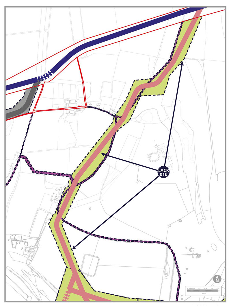
Longer Alternative Cable Route LACR-01b
As it heads north, our LACR-01 splits into two different potential routes. We would only need one of these routes if LACR-01 is ultimately chosen. We’ve called the western of these two routes LACR-01b and you can read about it and its potential environmental effects on this page and see a map on the page before. LACR-01b would connect from the north end of LACR-01a, travelling northwest initially and then turning northeast to eventually re-join our existing proposed cable route.
LACR-01b would head through agricultural fields, including through an extensive private nature conservation project (the “Peppering Project”), where new hedgerows are being planted in winter 2022/23.
Potential Environmental Impacts
LACR-01b introduces the potential for new effects on the environment, which are assessed in our PEIR SIR.
During the construction period, some bridleways and footpaths will need to be diverted for short distances or temporarily interrupted for a limited duration.
The route passes through the South Downs National Park, and one Landscape Character Area. The route also passes through five hedges or treebelts, which we will replant afterwards.
This alternate route and accesses will introduce new potential receptors into proximity in respect of air quality. Different homes nearby would also have the potential to be affected by noise and vibration caused by construction or construction traffic. This route may affect individual roads differently from our previous assessment in a limited way.
This route passes through arable and pasture fields, some of which are planned to be included in an extension to the Peppering Project, a Countryside Stewardship scheme. We would using additional mitigations including timing of works and hedgerow management, to reduce effects on ecology.
We do not think that this alternate route changes our assessment of soils and agriculture. Our research has not shown any new sources of ground contamination along this corridor.
There are no standing historic features along the route of the proposed cable, but there is potential for buried archaeology from all periods of time. If this route is selected, we would undertake further site surveys to help us plan how to address anything we might encounter. This section of the route could affect the setting of one listed building during construction.
At this stage, we have some concerns about the potential for fluid from our trenchless crossings to contaminate groundwater, due to fractures within the chalk bedrock in this area. Therefore if this route was selected, we would commit to undertake an established detailed process called a Hydrological Risk Assessment to establish ways to minimise potential effects.
All of the above receptors have been identified in our PEIR SIR as either new, or with the potential for a change, in relation to landscape and visual and water environment effects.
Tell us what you think. Do you have other things you want to highlight to us?
Area 4c: Our new route LACR-01c
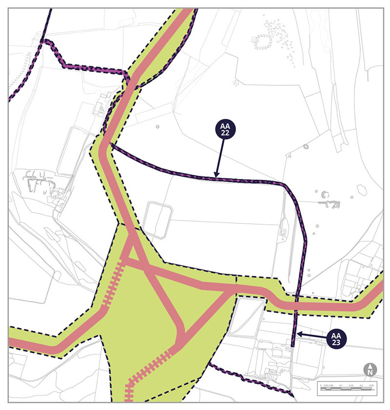
Alternative Accesses AA-22 and AA-23
Both AA-22 and AA-23 would be a temporary construction and operational accesses following existing estate tracks from the end of Michelgrove Lane to LACR-01. We have allowed for potential temporary passing places during construction on these acccesses if needed.
Area 4c: Our new route LACR-01c
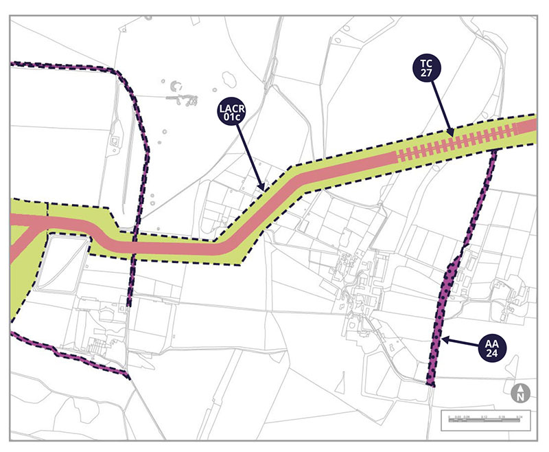
Longer Alternative Cable Route LACR-01c
As it heads north, our LACR-01 splits into two different potential routes. We would only need one of these routes if LACR-01 is ultimately chosen. We’ve called the eastern of these two routes LACR-01c and you can read about it and its potential environmental effects on this and the following pages. LACR-01c would connect from the north end of LACR-01a, travelling east initially and then turning northwest to eventually re-join our existing proposed cable route.
LACR-01c would head across agricultural land with an open trench crossing of Michelgrove Lane. Along some of its length it would run parallel to wooded areas and between buildings and a gallops. The boundary of LACR-01c includes width to create an access track beside field edges if the existing track is found to be unsuitable.
You can see the initial eastbound and north-easterly parts of LACR-01c on maps on the following pages.
Trenchless Crossings TC-27
TC-27 would be used to reach under the shoulder of Blackpatch Hill.
Alternative Access AA-24
AA-24 would allow access from Long Furlong Lane to LACR-01c for both construction and the operational life of the wind farm.
Area 4c: Our new route LACR-01c
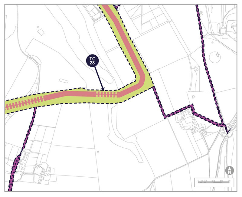
Trenchless Crossing TC-28
Alternative Access AA-27
AA-27 would be needed during the operational life of the wind farm. Located about 850m South of Cobden Farm, it would run between 2 adjoining fields along an existing farm track.
Area 4c: Our new route LACR-01c
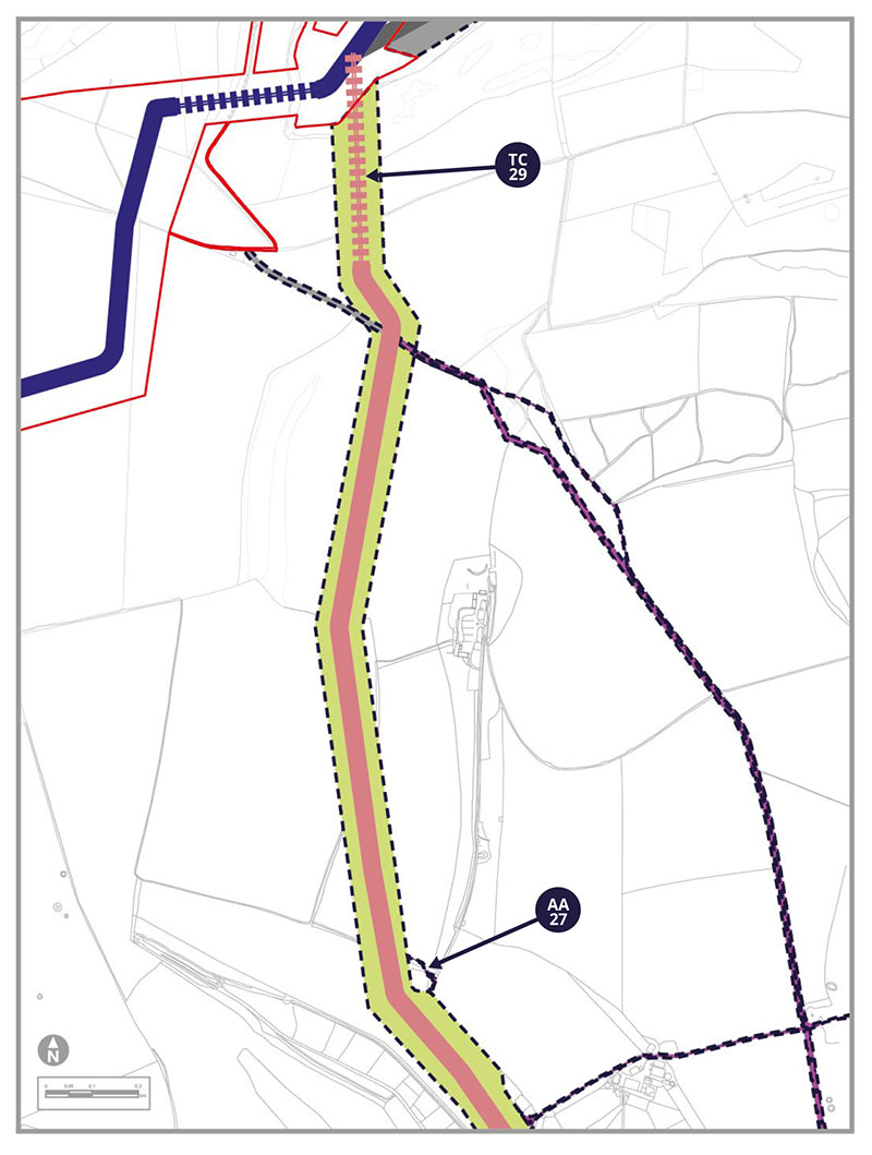
Trenchless Crossing TC-29
TC-29 would be required at the slope down Sullington Hill/Barnsfarm Hill for approximately 400m.
Potential Environmental Impacts
LACR-01c introduces the potential for new effects on the environment, which are assessed in our PEIR SIR.
During the construction period, some bridleways and footpaths will need to be diverted or temporarily interrupted, including the restricted byway 2092 to the west of Windlesham, albeit for a limited duration.
The route passes through the South Downs National Park, and two Landscape Character Areas. The route also passes through eighteen hedges or treebelts, which we will replant afterwards.
This alternate route and accesses will introduce new potential receptors into proximity in respect of air quality. Different homes nearby would also have the potential to be affected by noise and vibration caused by construction or construction traffic. We have assessed the transport impacts of this alternate route, which, when combined with LACR-01a, results in the most traffic. This route may affect individual roads differently from our previous assessment in a limited way.
This route passes through pasture and arable fields, including an area of good quality semi-improved grassland and also of lowland calcereous grassland, which are both considered Priority Habitats. We propose to use trenchless crossings to ensure these areas are retained, to reduce effects on ecology.
We do not think that this alternate route changes our assessment of soils and agriculture. We have not identified any new sources of ground contamination within this corridor. The work area would come close to Log Furlough, Findon, Landfill, but we consider the distance from the landfill site, and our usual construction measures will prevent the likelihood of contamination.
There are no standing historic features along the route of the proposed cable, but there is potential for buried archaeology from all periods, including prehistoric, Roman and medieval. If this route is selected, we would undertake further site surveys to help us plan how to address anything we might encounter. This section of the route could affect the setting of one listed building during construction.
At this stage, we have some concerns about the potential for fluid from our trenchless crossings to contaminate groundwater, due to fractures within the chalk bedrock in this area. Therefore if this route was selected, we would commit to undertake an established detailed process called a Hydrological Risk Assessment to establish ways to minimise potential effects.
All of the above receptors have been identified in our PEIR SIR as either new, or with the potential for a change, in relation to socio-economic, landscape and visual and water environment effects.
Tell us what you think. Do you have other things you want to highlight to us?
Area 4c: Eastern accesses to LACR-01
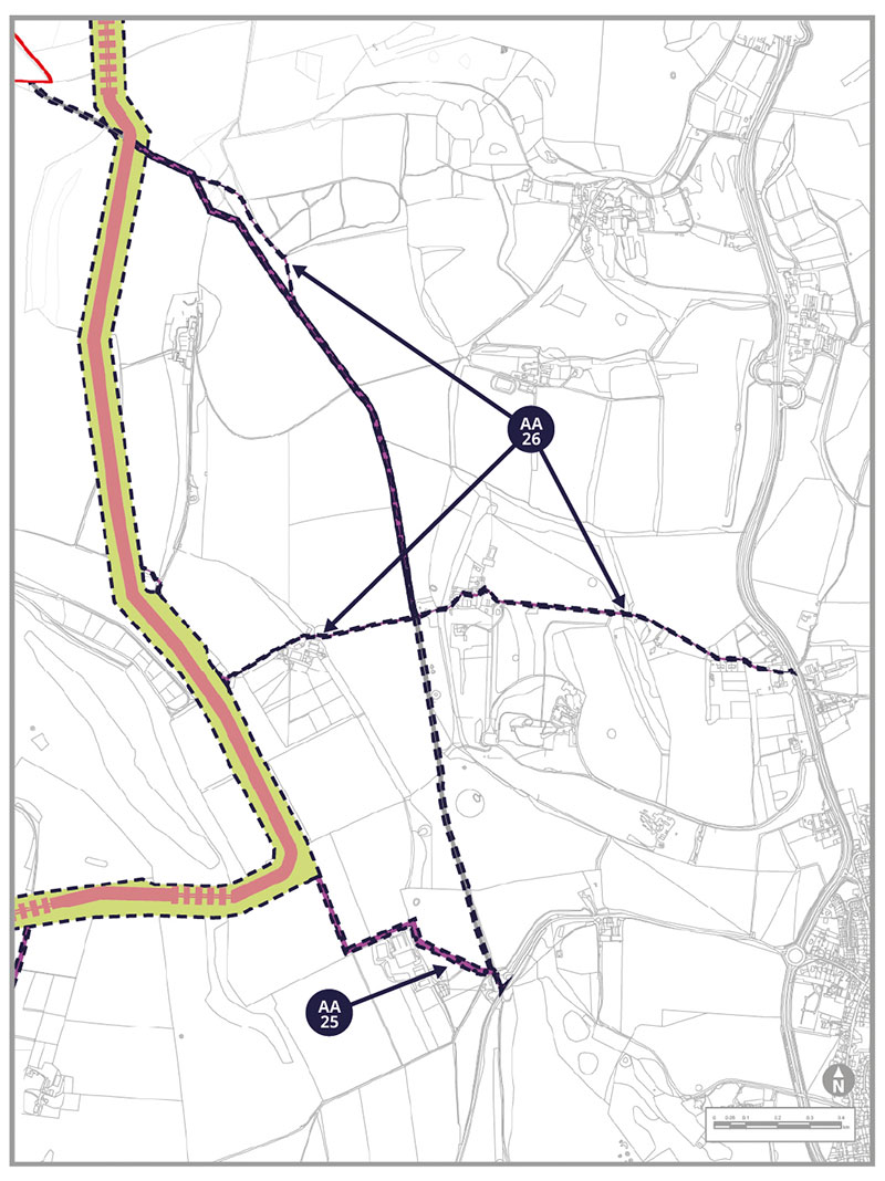
Alternative Access AA-25
AA-25 would allow construction and operational access from the A280 to LACR-01c. Within the proposed area we have allowed for potential extra width to create a new temporary stone road if needed rather than using the existing surfaced farm track during construction.
Alternative Access AA-26
AA-26 would be for access only during the operational life of the wind farm, using existing tracks and paths to reach the LACR-01c cable route. As it heads west the access would split into westerly and north-westerly routes to access different parts of our cable corridor, using existing tracks and paths where possible.