Area 2 – Lyminster to Sullington Hill (Modified Route)
Page Contents
Introduction
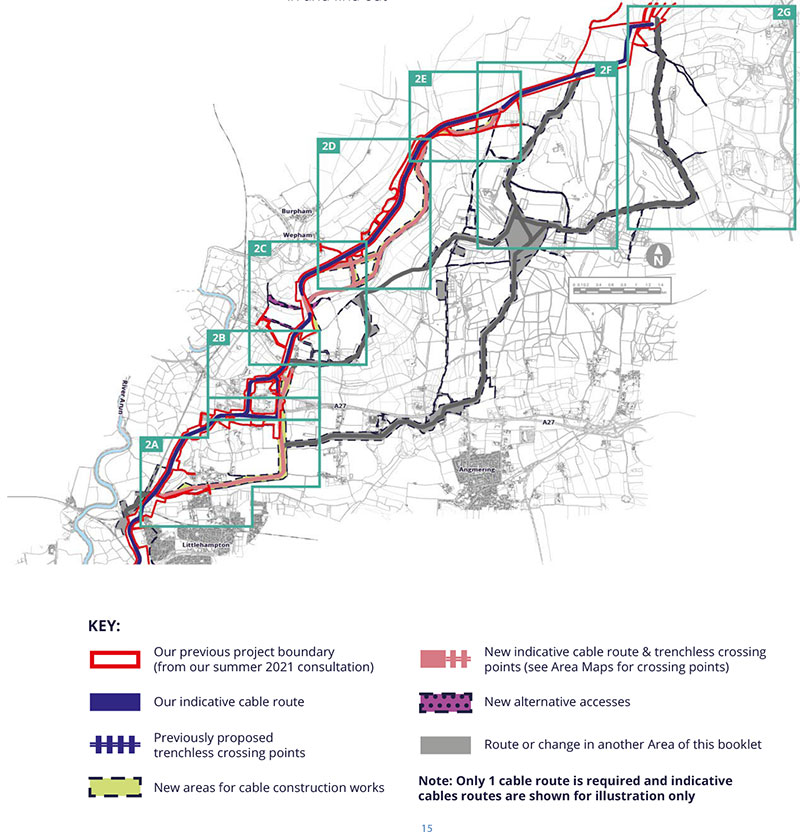
This Area considers the cable route between Lyminsterand Angmering Park, where we are consulting on five alternative cable route options, three modified routes, nine trenchless drill crossings and seven alternative accesses. They are all referenced on the following pages using the abbreviations here.
Area 2 addresses potential changes to the cable route that we consulted on last year, including some alternative cable routes. However, if you would like to also read about longer alternative cable routes we are considering which start in a similar place but would go further to the east, please have a look at Area 3 and 4 as well.
Our Environmental Assessment of Lyminster to Sullington Hill
On the following pages you can read about our preliminary assessment of potential changes in Area 2. We consider that introducing these changes would be likely to create new landscape and visual, water environment, ecological and historic environment (heritage) effects. You can read more about our consideration of these potential changes in our PEIR SIR at Formal Consultation Detailed Documents 2022 – Rampion 2. Just look for the relevant ACR, MR, AA or TC reference.
We’ve split this Area into 5 smaller Areas 2a to 2g. You can use the map below to figure out where you are most interested in and find out more on the following pages
Area 2a: South of Lyminster
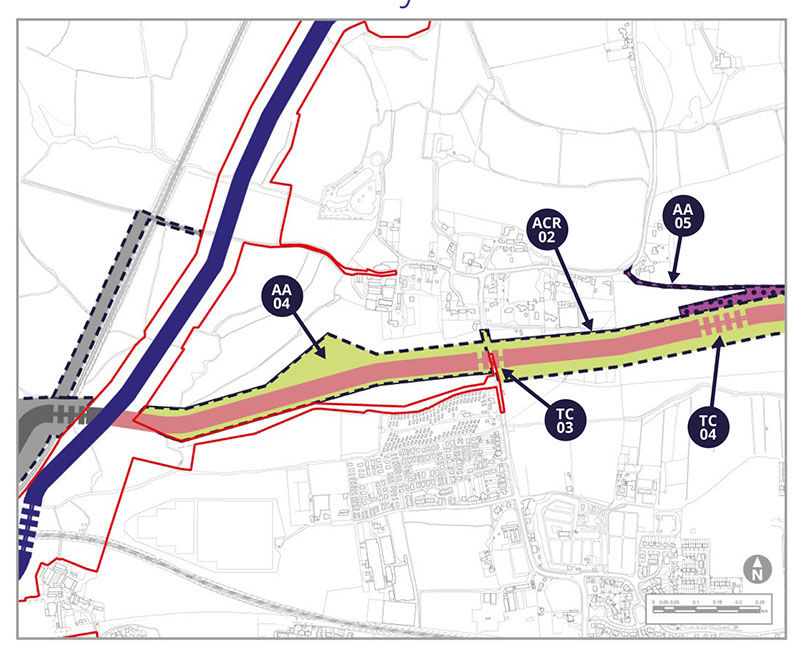
Alternative Cable Route ACR-02 & Alternative Access AA-04
ACR-02 has been introduced to avoid potential archaeological interests, specific agricultural issues and difficult or constrained working areas on our existing proposed route. AA-04 has been introduced to stay further away from Brookside Caravan Park when accessing our proposed cable route options to the west. AA-04 would sit in a similar area to ACR-02 from the west to the A284. AA-04 would only be taken forward if ACR-02 is not progressed.
Alternative Access AA-05
AA-05 would provide construction and operational access from the A284 Lyminster Road to ACR-02 and account for the future Lyminster Bypass.
Trenchless Crossings TC-03 and TC-04
For ACR-02 we would need trenchless crossings TC-03, under the A284, and TC-04, under the proposed Lyminster bypass, which is a separate project expected to complete before Rampion 2.
Potential Environmental Impacts
AA-04, AA-05, TC-03 and TC-04, along with the western part of ACR-02, have all been considered together. These would involve crossing public rights of way, bridleways, hedgerows, recreational paddocks, be in the vicinity of residential buildings and affect a different landscape character area. These receptors have been identified in our PEIR SIR as either new, or with the potential for a change, in relation landscape and visual, social economic, air quality, noise and vibration, transport and historic environment (heritage) effects.
Tell us what you think. Do you have other things you want to highlight to us?
Area 2a: East of Lyminster
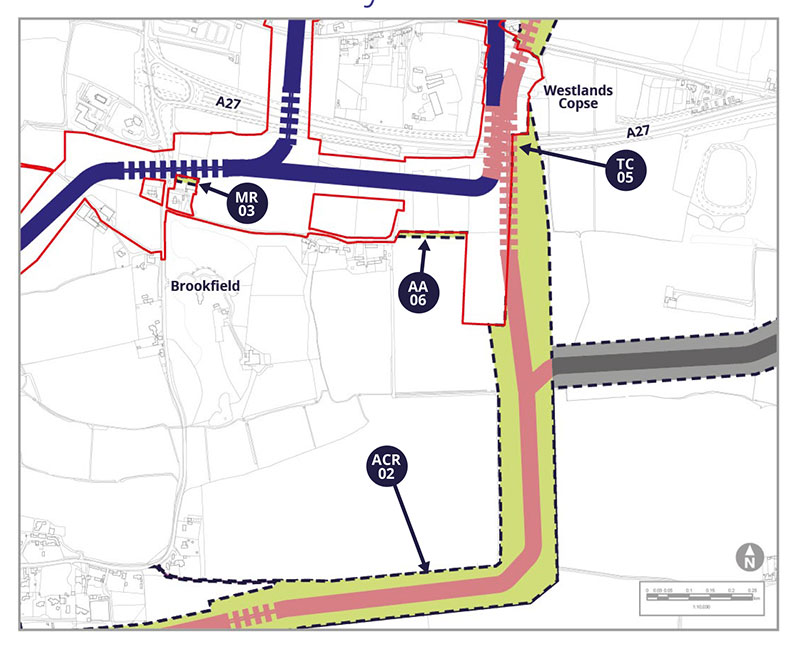
Alternative Access AA-06
AA-06 would provide operational access from the A284 Lyminster Road to ACR-02 along an existing track.
Modified Route MR-03
MR-03 is being included to allow for a change to the direction of the trenchless crossing under the A284, to avoid an area that has recently been granted planning permission for built development.
Trenchless Crossing TC-05
TC-05 is needed under the A27, whether we use our existing proposed cable route or our new potential alternative cable route ACR-02.
Potential Environmental Impacts
There are no associated new receptors or changes to impacts for MR-03 compared to those already identified in the 2021 consultation.
AA-06 and TC-05, along with the northern part of ACR-02, have all been considered together. These would involve crossing public rights of way, bridleways, hedgerows, recreational paddocks and be in the vicinity of residential buildings. As noted for the western part of ACR-02, These receptors have been identified in our PEIR SIR as either new, or with the potential for a change, in relation to landscape and visual, social economic, air quality, noise and vibration, transport and historic environment (heritage) effects.
Tell us what you think. Do you have other things you want to highlight to us?
Area 2b: East of Crossbush
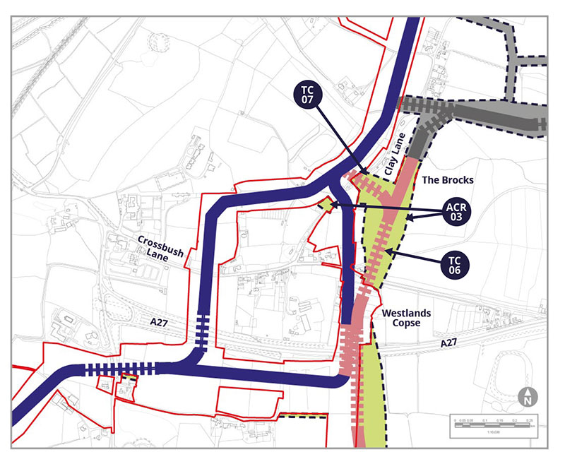
Alternative Cable Route ACR-03
North of the A27, the original eastern cable route option would cross a gas pipeline, which must be done as close to 90 degrees a possible. ACR-03 has therefore been identified, which takes the cable route further east so that it can cross at a better angle. ACR-03 also includes a small area to the west to support construction.
Trenchless Crossings TC-06 and TC-07
ACR-03 moves into an area of designated Ancient Woodland, which means trenchless crossing TC-06 is required under Crossbush Lane and the western edge of the woodland. Trenchless crossing TC-07 is required under Clay Lane and the gas pipeline.
Potential Environmental Impacts
ACR-03, TC-06 and TC-07 have been considered together. TC-06 would run under a replanted Area of Ancient Woodland and a Local Wildlife Site known as Poling Copse. Hedgerows are present within ACR-03 that are linked directly with ponds. One public right of way is crossed by the route and is in an area that is of interest to archaeologists (an Area of Archaeological Notification (ANA). These receptors have been identified in our PEIR SIR as either new, or with the potential for a change, in relation to landscape and visual, social economic, transport and historic environment effects.
Tell us what you think. Do you have other things you want to highlight to us?
Area 2c: Near the Warningcamp Hill to New Down Local Wildlife Site
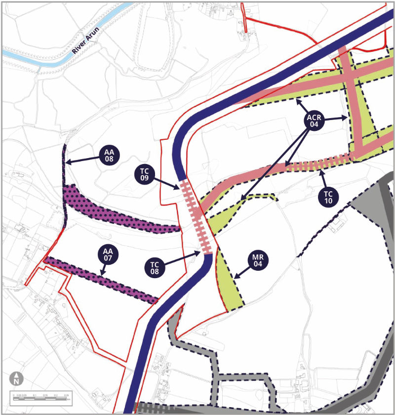
Alternative Accesses AA-07 and AA-08
AA-07 and AA-08 would be required from Burpham Road to reach TC-08 and TC-09 and minimise interaction with an environmental stewardship scheme. They would require new stone roads to be installed. AA-08 would be retained for the operational life of the wind farm.
Modified Route MR-04
MR-04 has been added just east of our original cable route to allow space to achieve trenchless crossing TC-08 in the valley at the Warningcamp Hill to New Down Local Wildlife Site.
Trenchless Crossings TC-08 and TC-09
TC-08 (south side) and TC-09 (north side) would allow us to drill on either side of the valley and have been introduced to significantly reduce impacts on the Warningcamp Hilll to New Down Local Wildlife Site and chalk grassland, which is a sensitive and rare habitat in Sussex.
Alternative Cable Route ACR-04 and Trenchless Crossing TC-10
ACR-04 includes many different potential routes where our cable would head east from the Warningcamp Hill to New Down Local Wildlife Site. We would only require one final route for our cables but might join these options up in different ways. ACR-04 also continues into Area 2d, so make sure you check out the proposals on the following pages as well.
One option on ACR-04 would leave our original route at the base of the valley north of TC-08, in a northeasterly direction along the route of the Monarch’s Way public right of way. This means that during construction the Way would need to be temporarily diverted. This option would require a further trenchless crossing TC-10 where it would otherwise run through Ancient Woodland in a narrower stretch of the Monarch’s Way.
To the east of TC-10, route ACR-04 could continue along the valley floor parallel to the Monarch’s Way (see Area 2d on the next page). Alternatively it could head north to rejoin our orignial proposed route on the north side of the valley.
Lastly, in this Area, ACR-04 could also peel off our existing proposed cable route after the bend north of TC-09 to join up with other ACR-04 options.
The area of ACR-04 which does not show an indicative cable route has been included to allow for a diversion of the route of the Monarch’s Way.
Remember, ACR-04 continues east onto Area 2d, so please go on to the next page.
Potential Environmental Impacts
MR-04 does not introduce any new receptors or changes in effects compared to those identified in the 2021 consultation. TC-10 would pass under the root protection zone of an Ancient Woodland (the Knoll). ACR-04 and its associated trenchless crossings (TC-08, TC-09 & TC-10) and Alternative Accesses (AA-07 & AA-08) would impact on heritage assets, public rights of way and an aquifer. These receptors have been identified in our PEIR SIR as either new, or with the potential for a change, in relation to socio-economic, traffic, noise and vibration, ecology and nature conservation, historic environment (heritage) and water environment effects.
Tell us what you think. Do you have other things you want to highlight to us?
Area 2d: Southeast of Wepham to Wepham Down
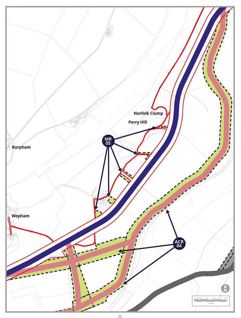
Alternative Cable Route ACR-04
ACR-04 would continue eastwards from Area 2c along two potential routes which quickly join together to run near the base of the valley.
Running near the valley floor, ACR-04 would be parallel to the Monarchs Way public right of way. ACR-04 has been included here to steer away from the middle of the fields to reduce impacts on a local shooting business and an extensive private nature conservation project (the “Peppering Project”). ACR-04 would continue northeast adjacent to the Monarchs Way until it merges with our original proposed cable route at Wepham Down.
Modified Route MR-05
MR-05 covers several areas that would extend the width of our previously proposed accesses. This would be to facilitate better field access for construction vehicles to feed cables under hedgerows. These modifications have been included to reduce disturbance to hedgerows in the Peppering Project and to a commercial business.
Potential Environmental Impacts
ACR-04 and its associated trenchless crossings (TC-08, TC-09 & TC-10) and Alternative Accesses (AA-07 & AA-08) on the previous pages have been identified in our PEIR SIR as either affecting new, or with the potential for a change to receptors, in relation to socio-economic, traffic, noise and vibration, ecology and nature conservation, historic environment (heritage) and water environment effects.
There are no new receptors for MR-05 compared to those already identified in the 2021 consultation.
Tell us what you think. Do you have other things you want to highlight to us?
Area 2e: Wepham Down to Lee Farm
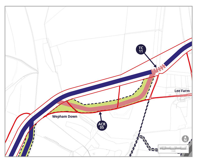
Alternative Cable Route ACR-05
From Wepham Down, ACR-05 has been introduced to provide a potential alternative route to the south of our original proposal, skirting around the southern edge of the field boundary to protect the Beetlebank Environmental Stewardship Scheme. This alternative would retain a 25m buffer to an adjacent area of Ancient Woodland, to protect the root system.
Trenchless Crossing TC-11
On our original proposed route, just east of where ACR-05 would rejoin if used, we have introduced a proposed trenchless crossing TC-11. This is to pass under a woodland area that is related to a nearby Special Area of Conservation. This means we could help protect the qualities for which the area has been designated.
Potential Environmental Impacts
ACR-05 introduces the need for assessment of a new bridleway at Barpham Hill and a former medieval leper settlement, which is a site of historic interest.
These receptors have been identified in our PEIR SIR as either new, or with the potential for a change, in relation to socio economic, transport and historic environment (heritage) effects.
Tell us what you think. Do you have other things you want to highlight to us?
Area 2f: Eastern accesses to Area 2
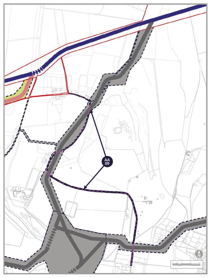
Alternative Access AA-09
AA-09 would be a temporary construction and operational access from the A280 in the south (north of Clapham) to the original PEIR Assessment Boundary towards Sullington Hill. The access would run via existing estate roads and tracks with no new larger entrance associated with this access. AA-09 includes provision for new passing places and has been introduced in response to further engineering studies by Rampion 2.
Area 2g: Eastern accesses to Area 2
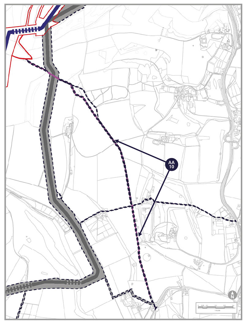
Alternative Access AA-10
AA-10 would be a temporary construction and operational access from the existing access at the A280 in the south (west of Findon) to the original PEIR Assessment Boundary towards Sullington Hill. From the A280, the first 1,200m of AA-10 would run alongside a restricted byway (2092) on a new temporary stone road, 1,100m along an existing farm track, and 1,300m on a new temporary stone road. AA-10 has been introduced in response to further engineering studies.