Area 6 – Wiston to Kings Lane
Page Contents
Introduction
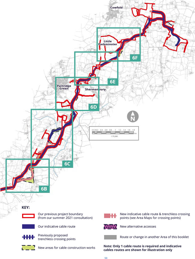
This Area considers the cable route from the west side of Wiston to Kings Lane. It includes [one modified route (MR), three new trenchless crossings (TCs) and one alternative access (AA)]. They are all referenced on the following pages using the abbreviations here.
Our Environmental Assessment of Wiston to Kings Lane
On the following pages you can read about our preliminary assessment of potential changes in Area 6. We don’t believe that introducing these changes is likely to change the overall conclusions of our PEIR from summer 2021. You can read more about our consideration of these potential changes in our PEIR SIR. Just look for the relevant MR, AA or TC reference.
We’ve split this Area into 6 smaller Areas 6a to 6f. You can use the map to figure out where you are most interested in and find out more on the following pages
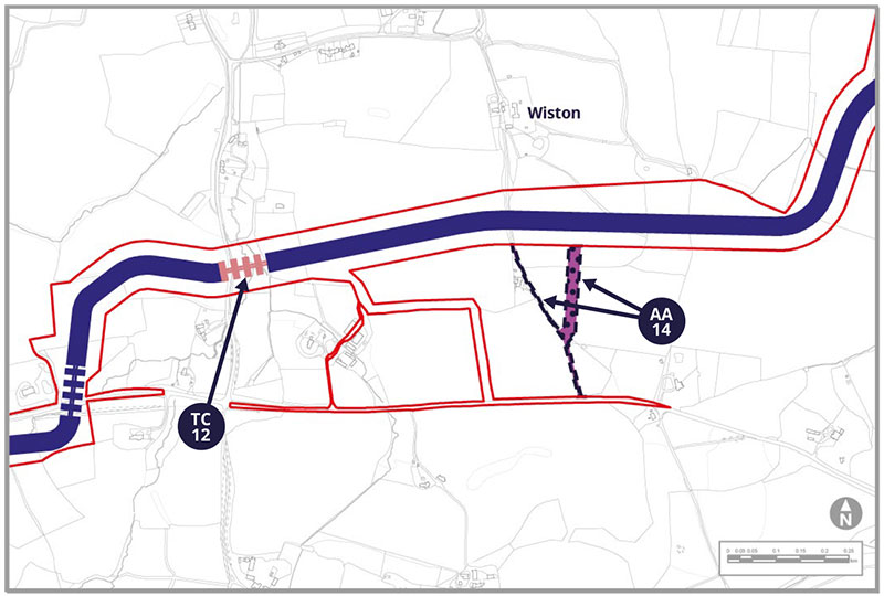
Alternative Access AA-14
East of Water Lane, our original construction access proposal would run from the A283 passing a residence. We are now exploring AA-14 as an alternative construction access (from the road via the wider northwest section) because it would avoid crossing a gas main and would affect less agricultural land, along with some traffic and minerals protection advantages.
The narrower part of AA-14 may also be used for operational access for the life of the wind farm.
Trenchless Crossing TC-12
TC-12 has been added to pass under Water Lane and a tributary of the Honeybridge Stream without affecting them and would reduce the effect if the cable route on Ancient Woodland.
Potential Environmental Impacts
AA-14 would cross a hedgerow, an arable field and pass in the vicinity of two listed buildings. It creates new access to the A283. These receptors have been identified in our PEIR SIR as either new, or with the potential for a change, in relation to socio-economic, landscape and visual, ecology and nature conservation, and historic environment (heritage) effects on the identified receptors are considered in the PEIR SIR.
TC-12 has been added to pass under Water Lane and a tributary of the Honeybridge Stream without affecting them and would be drilled under Ancient Woodland. Receptors have been identified in our PEIR SIR as either new, or with the potential for a change, in relation to landscape and visual, air quality, noise and vibration, ecology and nature conservation and transport effects.
Tell us what you think. Do you have other things you want to highlight to us?
Alternative Cable Route ACR-06 and Trenchless Crossings TC-13 and TC-14
ACR-06 would be located south of Ashurst, running west of Horsham Road and alongside Spithandle Road. ACR-06 is to the east of the original cable route and has been introduced to potentially avoid ponds, environmental and engineering constraints. and impacts on a private nature conservation
scheme. ACR-06 would require new trenchless crossings TC-13 to cross Calcot Wood and TC-14 to cross Horsham Road and a tributary of the River Adur.
Potential Environmental Impacts
ACR-06 is in the vicinity of Horsebridge Common, comes within 350m of residential buildings and is in the vicinity of listed buildings. These are new receptors and have been considered by our latest assessments. The cable route will be closer to three listed buildings.
These receptors have been identified in our PEIR SIR as either new, or with the potential for a change, in relation to socio-economic, air quality, historic environment (heritage) and noise and vibration effects.
Tell us what you think. Do you have other things you want to highlight to us?
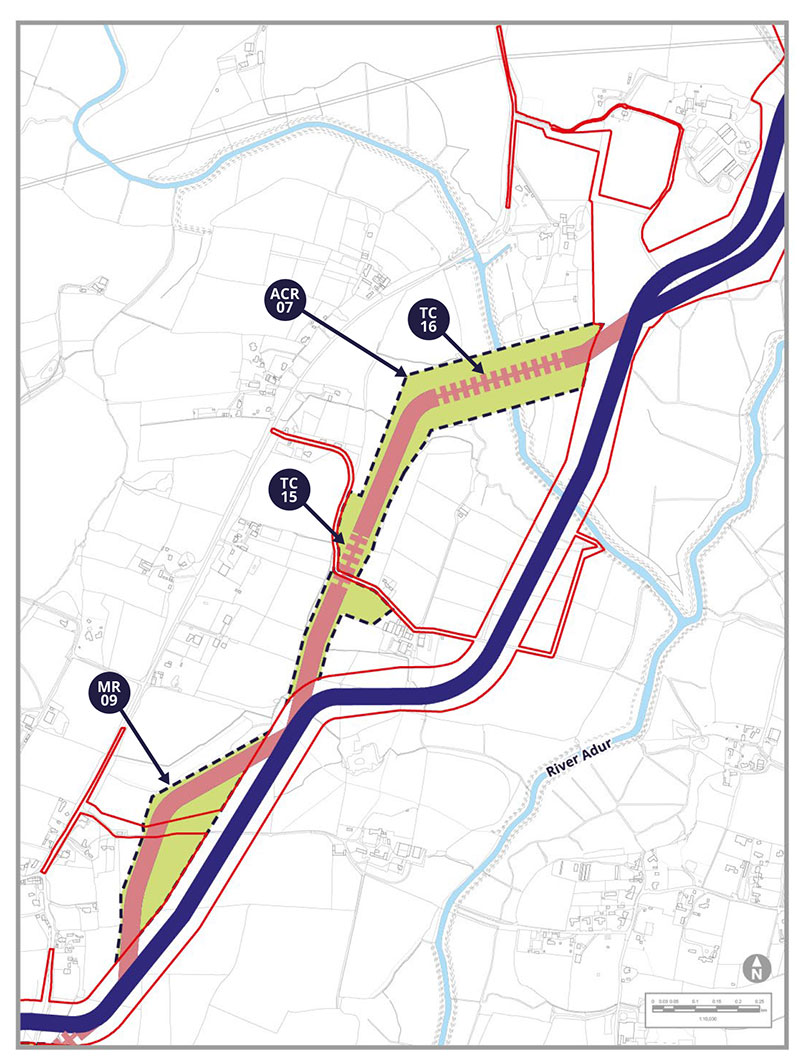
Modified Route MR-09
MR-09 extends the potential cable route to the west, bringing it closer to Ashurst. This has been introduced to reduce the severance of agricultural fields and maximise their use during construction.
ACR-07 and Trenchless Crossings TC15 and TC-16
ACR-07 is located approximately 220m east of Bines Green, west of the original cable route. This alternative would cross agricultural fields, including trenchless crossing TC-15 of a farm access track and mature treeline. It would then continue northeast to cross the River Adur via trenchless crossing TC-16, before rejoining the original cable route.
ACR-07 has been introduced to potentially avoid new infrastructure under construction and in response to challenges crossing utilities on the route that we consulted on last year.
Potential Environmental Impacts
MR-09 would bring the modified cable route marginally closer to Ashurst, with some mature trees on its boundary, and in the vicinity of two listed buildings. These receptors have been identified in our PEIR SIR as either new, or with the potential for a change, in relation to landscape and visual, ecology and nature conservation and historic environment (heritage) effects.
Construction works for ACR-07 would be visible from footpath 2519 and Bines Green Common. The footpath may also be interrupted by works. The change would introduce new residential receptors for air quality and for noise and vibration along the B2135 Bines Road, and could affect the setting of two listed buildings. The works would take place within a Habitat of Principal Importance – coastal and floodplain grazing marsh. These receptors have been identified in our PEIR SIR as either new, or with the potential for a change, in relation to socio economic, air quality, noise and vibration, ecology and nature conservation, transport and historic environment (heritage) effects.
There are no associated new receptors or changes to impacts from TC-15 and TC-16 compared to those already identified in the 2021 consultation.
Tell us what you think. Do you have other things you want to highlight to us?
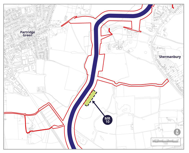
Modified Route MR-10
MR-10 is a proposed extension to the east of our original proposed cable route, to provide a topsoil storage area during construction outside of the nearby floodplain.
Potential Environmental Impacts
There are no associated new receptors or changes to impacts associated with MR-10, compared to those already identified in the 2021 consultation.
Tell us what you think. Do you have other things you want to highlight to us?
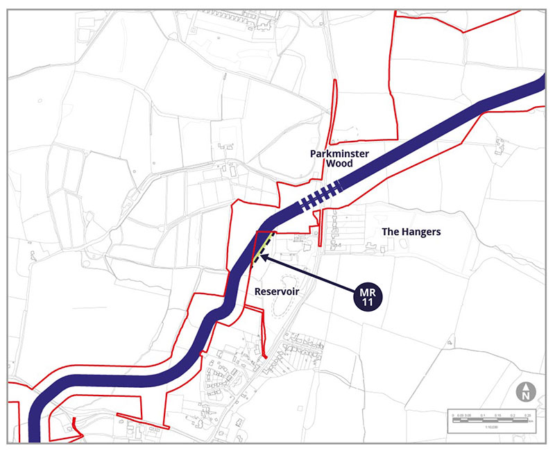
Modified Route MR-11
MR-11 is a proposed eastern extension to our cable corridor to allow the onshore cable working area to run closer to the field boundary. This would reduce severance, maximise the remaining agricultural use during construction and allow a slightly shorter cable route.
Potential Environmental Impacts
There are no associated new receptors or changes to impacts from MR-11 compared to those aready identified in the 2021 consultation.
Tell us what you think. Do you have other things you want to highlight to us?
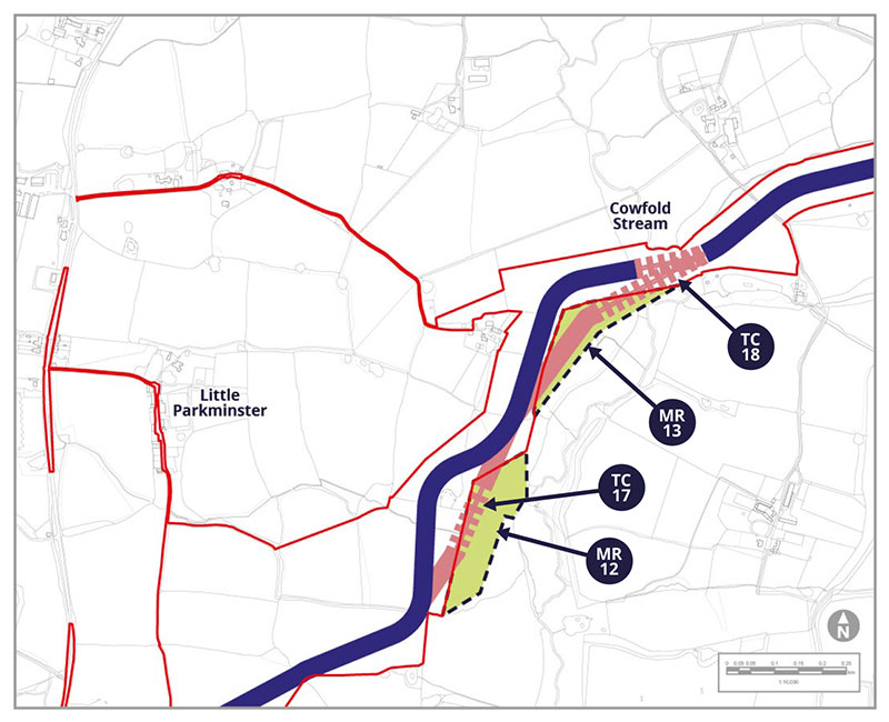
Modified Route MR-12 and Trenchless Crossing TC-17
MR-12 has been introduced to enable the onshore cable corridor to take a more direct route. It includes a trenchless crossing (TC-17) of a tributary of Cowfold Stream and hedgerows classed as Important under the Hedgerow Regulations, so that they are not affected.
Modified Route MR-13
MR-13 has been added to enable a trenchless crossing (TC-18) of hedgerows, mature trees and the Cowfold Stream. This would also move the corridor further east away from residential properties.
Trenchless Crossing TC-18
TC-18 would pass under hedgerows, mature trees and the Cowfold Stream to leave them unaffected.
Potential Environmental Impacts
MR-12 and TC-17 would be in a medium or high risk flood area and would interact with hedgerows and a pond. MR-13 would be in an area of medium flood risk and where there is evidence of three small areas of ground being dug up in the past – which could mean a higher risk of contamination or ground instability.
MR-13 would also interact with additional ponds. These receptors have been identified in our PEIR SIR as either new, or with the potential for a change, in relation ecology and nature conservation, ground conditions and water environment effects.
Tell us what you think. Do you have other things you want to highlight to us?


