Explore our video of the Rampion onshore cable route reinstatement

Scroll down to see our interactive map of the cable route and select the section of the route you would like to watch.

Alternatively, scroll down below the map to watch the video in its entirety.

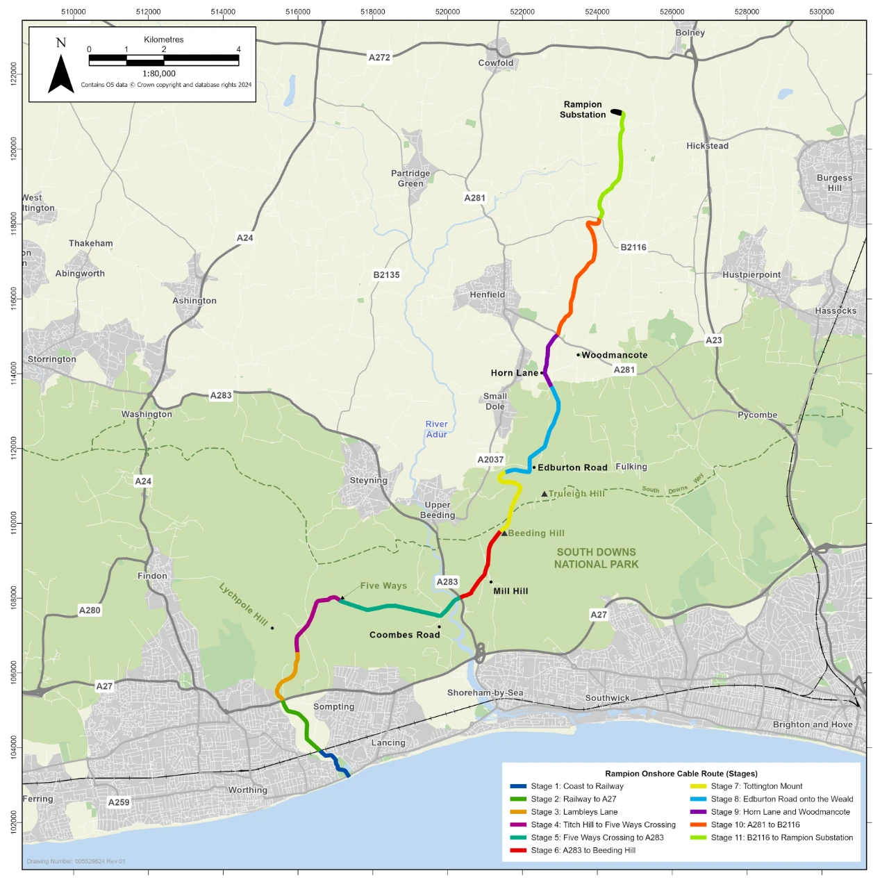
The 27-kilometre Rampion onshore cable route starts at Brooklands Pleasure Park in Worthing and follows a course under the railway, the A27 and the River Adur before heading northeast past the Old Cement Works, across the South Downs and the Weald to a new, purpose built Rampion Substation before final connection into the nation’s transmission grid at Bolney Substation in Mid Sussex.

Cable route reinstatement was completed in 2019, and the project is now halfway through a 10-year monitoring and management plan, meaning the land will continue to be monitored every year until 2029 with additional planting and seeding undertaken, if required.

The Rampion cable route is entirely underground so whenever you can see overhead lines and pylons in the video footage, these are unrelated to the Rampion cable circuits which are buried underground for the entire route. For Rampion 2, we will bury the cables underground again so any inconvenience will be temporary, during construction only, with the land fully reinstated.


Feeling fascinated by the technology?

If you are interested in how the original Rampion Wind Farm works and you and your family want to learn more, please book a trip to the fantastic Rampion Visitor Centre in Brighton.

Stage 11: B2116 to Rampion Substation

On the final approach to the Rampion Substation, the underground cable route passes pylons and overhead lines unrelated to the Rampion cable circuits.

The cable route passes under Bob Lane in Twineham to reach its final destination – the new Rampion Substation.

The substation transforms the power to the correct voltage and frequency to enable connection into the nation’s transmission grid at Bolney Substation, lying just beyond.

Stage 10: A281 to B2116

The cable route continues through mixed agricultural land across the Weald.
 
The only telltale sign of the cable route are some replanted hedgerows which have yet to reach full maturity.

Stage 9: Horn Lane and Woodmancote

The underground cable route crosses Horn Lane and runs parallel to a series of pylons and overhead lines unrelated to the Rampion cable circuits, continuing en route past Woodmancote.

Stage 8: Edburton Road onto the Weald

Passing along the foot of the Downs the cable route runs parallel to Edburton Road before turning north to cross it.
 
Rampion provided fencing during construction and some landowners have chosen to retain the separate fenced parcel of land which you can see as we cross paddocks and grazing land.

The pylons and overhead lines towards the end of this stage are unrelated to the Rampion cable circuits which are buried underground for the entire route.

Stage 7: Tottington Mount

As we come over the top of Beeding Hill and cross the South Downs Way, you can catch a glimpse of the Weald for the first time.
 
Over Tottington Mount, the cables needed repairs in 2020 which disturbed the reinstatement but it’s now settling in well again.
 
And as we traverse down the steepest section of the cable route, we’re given an expansive view across the Weald in all its glory.

Stage 6: A283 to Beeding Hill

The route now climbs through arable and grazing land as it passes the Old Cement Works on the left.
The pylons on the horizon are unrelated to Rampion’s cable circuits as the underground cable route crosses Mill Hill on its approach to the summit of Beeding Hill.

Stage 5: Five-Ways Crossing to A283

Stage 4: Titch Hill to Five-Ways Crossing

The cable route heads downhill from Lychpole Hill, giving an expansive view of grazing land over the South Downs as it crosses Titch Hill lane in the valley bottom.

The underground cable route then climbs up again to reach another high point at the Five-Ways Crossing of public rights of way, passing under pylons and overhead lines unrelated to the Rampion cable circuits.

Stage 3: Lambleys Lane

The cable route leaves the A27 behind and heads north over agricultural land then northeast to cross Lambleys Lane and over the crest of Lychpole Hill.

Stage 2: Railway to A27

The pylons and overhead lines at the start of this stage are unrelated to the Rampion cable circuits which are buried underground for the entire route.

This section routes the cables across agricultural land towards the A27, avoiding the settlements of Worthing and Sompting and keeping clear of individual homes.

Stage 1: Coast to the railway

Full length video of the entire cable route

Stage 1 - Bolney Substation

Lorem ipsum dolor sit amet, consectetur adipiscing elit. Ut elit tellus, luctus nec ullamcorper mattis, pulvinar dapibus leo.

Skip to content