Consultation Proposals
This targeted consultation presents a potential alternative to a section of our onshore cable route.
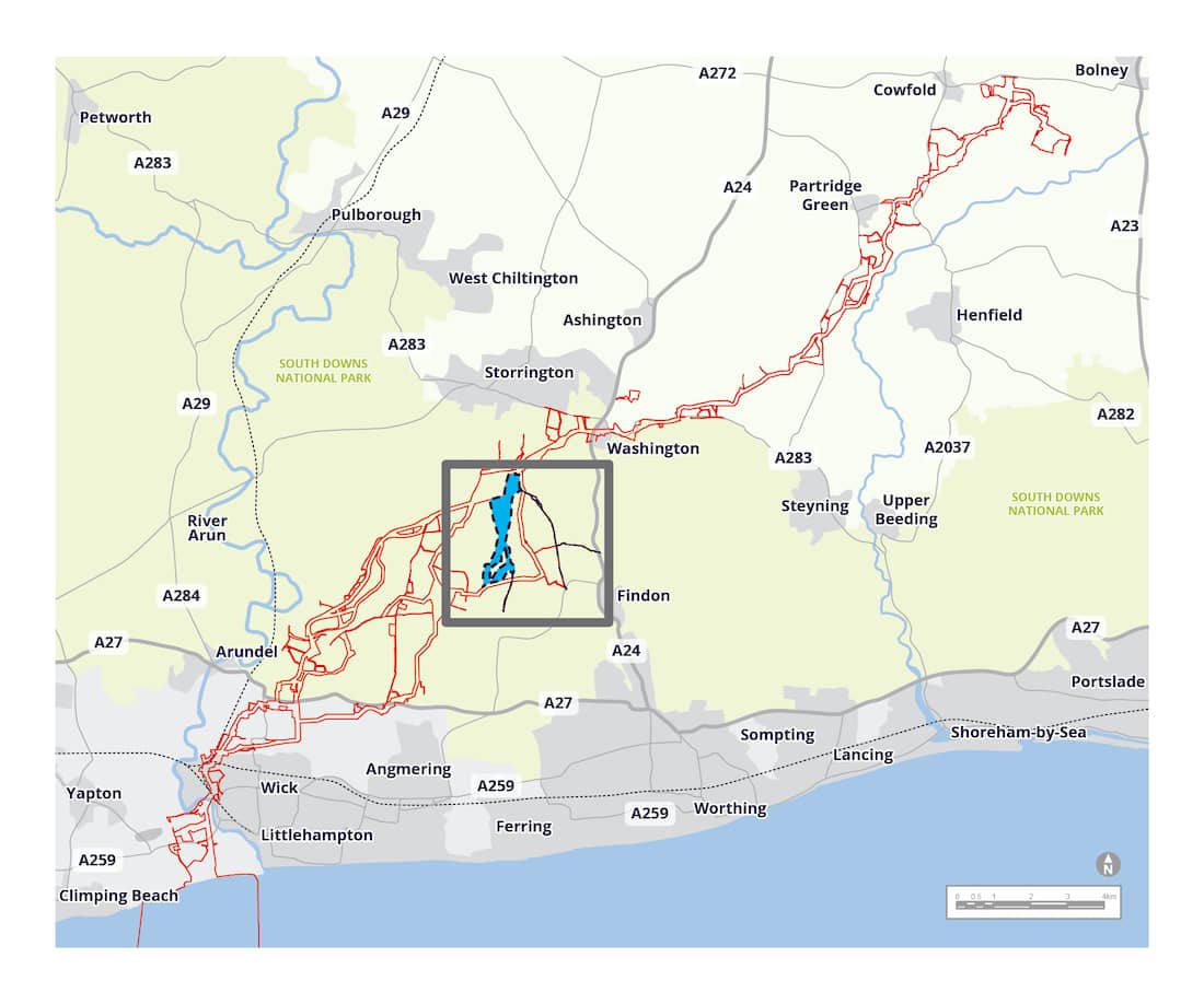
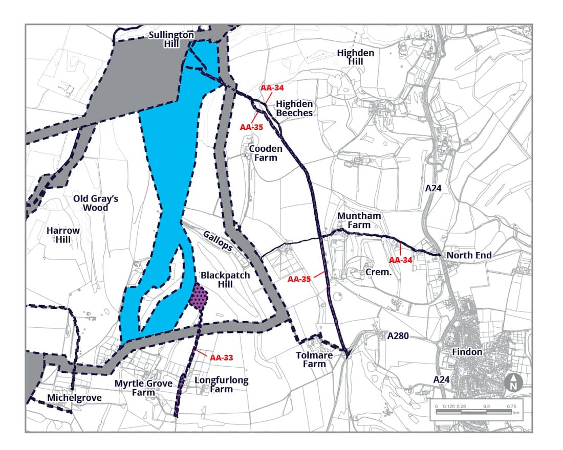
This is focussed on a 3km section in the South Downs, north of Patching.
Table of Contents
Introduction to this Consultation
This consultation is limited to a potential alternative to part of our onshore cable route. The onshore cable route would cover an overall distance of approximately 40km, but the works to install the cables would only be temporary. The land affected by the installation works would be fully restored back to its former condition once complete, other than occasional access covers for maintenance.
We are doing this consultation because of feedback we have received from our previous consultations and ongoing engagement, along with our own engineering and environmental work, in this part of the cable route.
We have created a corridor for an alternative cable route in the South Downs. We would install around 3km of cables underground within this corridor, which is an alternative to our previous routes in the area. The exact location of the cable within this corridor would be informed by feedback and further technical work.
Here you will find a summary of the new potential alternative and where it is on the overall cable route. You can respond based on this, or you can read more in our technical consultation document. This includes more detailed information about potential environmental effects associated with this potential change in our “Preliminary Environmental Information Report – Further Supplementary Information Report’ (or ‘PEIR FSIR’ for short). The PEIR FSIR adds environmental information about this new potential alternative to the PEIR and PEIR SIR we consulted on previously.
The potential alternative to the onshore cable corridor is the focus of this consultation. All feedback received will be considered alongside the feedback already received on our original cable route proposals. This will help us reach a final decision on whether to adopt this potential alternative for our final proposals, which we will submit in our consent application in summer 2023.
We use some technical terminology in the remainder of this consultation. Please do read the ‘definitions’ at the bottom of this page if this helps.

Proposals for consultation
We are consulting on a further potential cable corridor in the South Downs in the vicinity of Longfurlong, north of Patching.
This is the area in which we previously presented our Longer Alternative Cable Routes (LACR) 1b and 1c.
Our corridor would link to LACR-01c on which we consulted last year and described in the PEIR SIR. It would leave at Myrtle Grove in the south and re-join at Sullington Hill in the North. This means that this section of route is part of LACR-01, which we presented at our supplementary consultation last Autumn 2022.
For consistency, we have named this section LACR-01d. We are also interested in your comments on potential construction and/or operational access routes shown on the plan.
Longer alternative cable route 01D
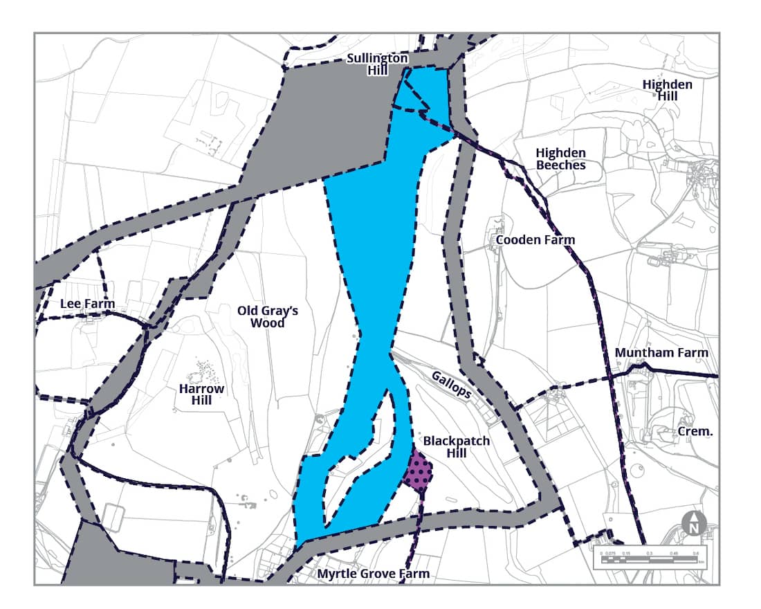
LACR-1d is approximately 3km in length and cable installation works would be undertaken by open-cut trenching. While our working area would be no more than 50m wide, we are presenting a wider corridor within which this cable route could go.
This corridor contains two branches to the south, and a broad area to the north. We will determine a more precise cable route within this corridor taking into account feedback from this consultation and further technical work.
Southern end
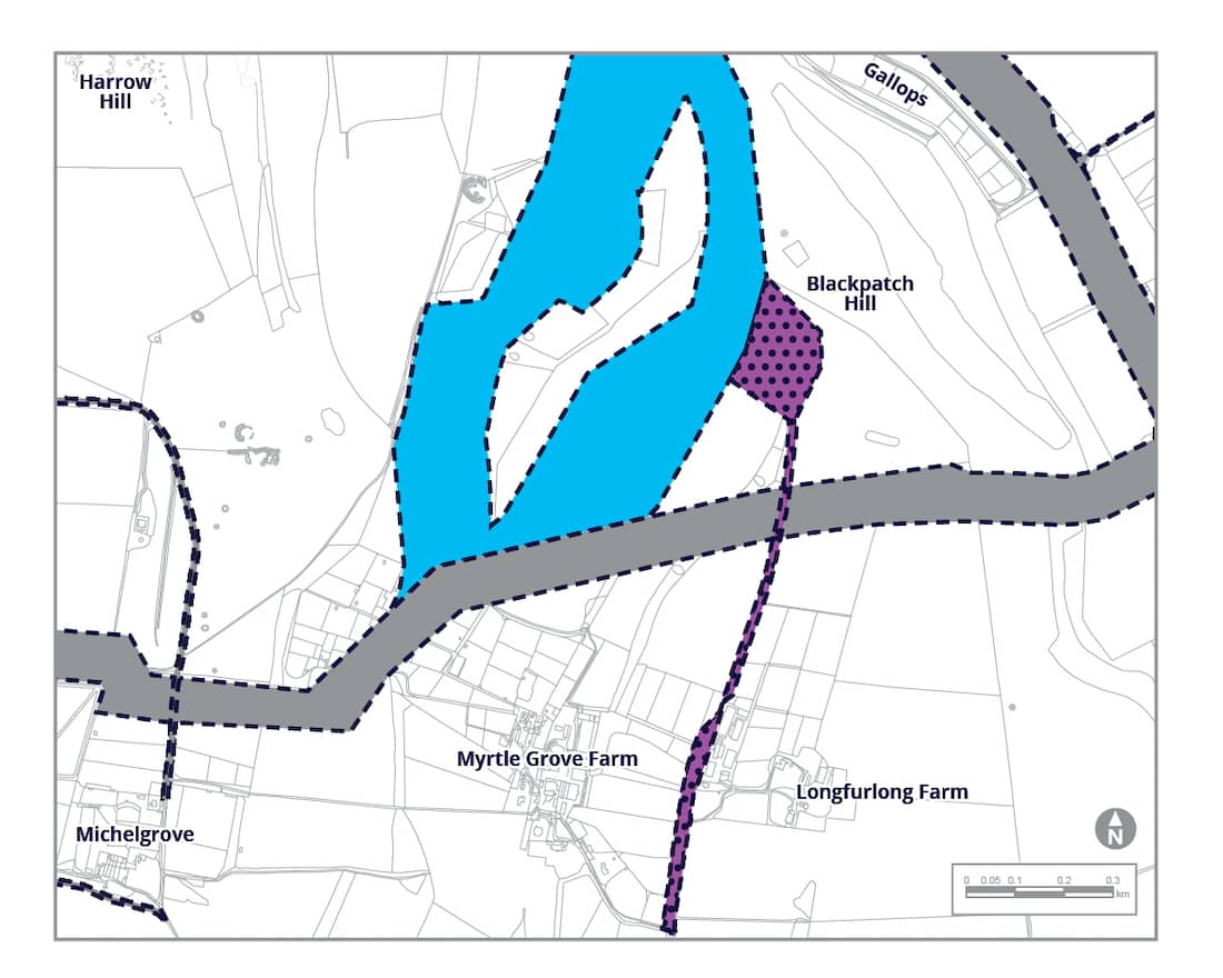
In the south, our potential cable corridor leaves our LACR-1c in the vicinity of Myrtle Grove Farm in Patching Parish. The two branches of the corridor run to the north, and the north east, separated by an escarpment. Only one of these branches would be used for the cable route.
The western branch would run up the valley between Harrow Hill and Blackpatch Hill. The eastern branch would skirt Blackpatch Hill, avoiding the summit. Both branches would need to cross bridleway 2173, and footpath 2262, both of which would also have been crossed by LACR-01c.
The branches combine at the Gallops north of Blackpatch Hill. Most of the cable corridor in this area would be in open fields.
Northern end
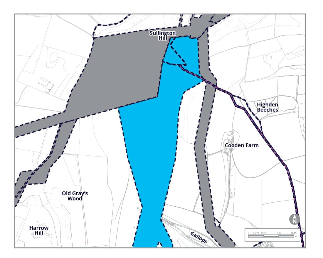
To the north, the corridor broadens out between bridleway 2173 and a gulley to the east. This area rises from south to north up to the ridge of the South Downs Way at Sullington Hill. If the cable is located to the western side of the corridor, it would cross bridleway 2282/4, which would also have been crossed by our previously consulted cable route.
The cable would then re-join our cable route either to the east, joining LACR-1c, or to the north, on the route consulted on in 2021. In this area, it may then also cross other public rights of way, in the same way that our previously consulted routes would have.
As previously consulted, we would use horizontal directional drilling to take the cable down Sullington Hill. Most of the cable corridor in this area is in open fields.
Construction and operational access
We will require access for construction, and for operational maintenance. Construction access will be used for the construction period only, and may be used by heavy vehicles. Access for operational maintenance may be needed occasionally by lighter vehicles once the project is up and running.
We are proposing to use the same access points for LACR-1d as we previously consulted for LACR-1c, but with the routes extended to reach the new potential cable corridor. To the south we would use Alternative Access AA-33 from Longfurlong Lane as a construction access, and also retain rights to use the route for operational access. To the east we would use Alternative Access AA-35 from an existing access on Longfurlong (the A280) for construction.
We would use a modified version of this, Alternative Access AA-34 from the A24 at North End past Muntham Farm, as our permanent operational access.
Potential Environmental Impacts
LACR-01d introduces the potential for new effects on the environment, which are assessed in our PEIR FSIR (click the link below to read this). This document also presents mitigation measures embedded into our design, which would reduce these impacts.
During the construction period, some public rights of way will need to be temporarily diverted or interrupted, including the South Downs Way. We would seek to reduce these impacts, but currently consider this is likely to have a significant impact over what we had previously assessed.
The route would pass through the South Downs National Park and two Landscape Character Areas. The route would also pass through several hedgerows and treelines (depending on alignment) which we would replant afterwards. We consider that the construction phase of our project is likely to result in a significant temporary effect on landscape, both in this location and for our other previously consulted routes in this area.
Like the other longer alternative cable routes we consulted on last year, this route and accesses will introduce a small number of new potential receptors into proximity in respect of air quality. We do not think that there will be any change in the noise effects previously assessed, and we expect the traffic impacts to be within the levels that we have already assessed.
This route passes through pasture and arable fields, including some semi-improved grassland. This may be considered a Priority Habitat if in good condition, but this will need further survey work to confirm. At the northern end is the Sullington Hill Local Wildlife Site, in which we would use trenchless crossing to minimise impacts on ecology.
We do not think that this alternate route changes our assessment of soils and agriculture. Nor have we identified any new sources of ground contamination within this corridor. Since our last consultation, a hydrogeological risk assessment has been undertaken, which concludes that there would likely not be any significant effect on the water environment.
There are no existing built historic features along the route of the proposed cable, but there is potential for buried archaeology from all periods, including prehistoric and Roman. If this route corridor is selected, we would undertake further site surveys to seek to avoid identified features, and help us plan to address anything we might encounter.
Considering the implementation of embedded environmental measures that we have included, we have identified new or different significant residual effects which would alter the assessment outcomes and conclusions presented in the PEIR for socio economics, LVIA, and historic environment. You can read more detail about how we reached these conclusions at the PEIR FSIR link below.
Technical Consultation Documents
Definitions
Longer Alternative Cable Route (LACR):
Just north of Lyminster we previously introduced two much longer alternative cable routes several kilometres in length, so we have named them differently to make them clearer.
Option 01d forms part of one of these LACR.
Alternative Access (AA):
New accesses for construction and/or operation which we are considering to get access from the local highway network.
Open trenching:
Most of our cable route will be installed by digging a trench and putting ducts in. Ducts are like tubes that we join together. The cables are then pulled through the ducts later. Using ducts allows us to dig shorter trenches at a time and reinstate the ground above them more quickly.
Trenchless crossing (TC):
In some locations we will need to drill or bore under obstacles such as rivers, railways and Climping Beach. This avoids disturbing the environment above or stopping transport services. A temporary drilling construction compound is needed at each end of the works.
Receptors:
Something that could be affected by our works, for example, a property or nature conservation site that might hear construction noise. We identify receptors to understand the potential effect of our project.
Cable route:
The route for our electricity cables from the landfall to the Bolney substation, via our own onshore project substation. The cables would be laid underground over a normal construction width of 50m, including our temporary construction works and the 20m permanent space we need for cables.
Cable corridor:
A wider corridor is often shown beyond our cable route, to allow flexibility, which we will decide whether to keep after our consultation.
Construction traffic:
This could run along our actual cable route, dedicated access routes we create, or on the local highway network.
Construction access:
Used for construction vehicles to get to our cable route from the local highway network.
Operational access:
Used by vehicles to monitor or maintain our cables during operation of the wind farm.
PEIR:
Our Preliminary Environmental Information Report (PEIR) is an initial assessment of the original project, consulted on in summer 2021.
PEIR SIR:
Our PEIR Supplementary Information Report (SIR) provided extra information on the changes that were the subject of our autumn 2022 consultation.
Work Plans:
Plans prepared to show the general categories of works in the new area we are consulting on.