
In 2018 The Crown Estate, landlord of the seabed, invited operators of existing offshore wind farms to consider potential extensions to those wind farms. An application for an Agreement for Lease was submitted to secure an area to the west of the existing Rampion project, in addition to having a second look at some of the original Zone 6 area awarded in 2010 (to the east and south of the operating Rampion project). More of the Zone 6 area may now be commercially viable for development due to the rapid advancement of the foundation technology and construction methods in deeper waters, set against the reduction in costs of offshore wind, which have halved in the last 2 – 3 years.
There are 40+ offshore wind farms around the UK with the majority being in the North Sea, but there is only one off the south coast of England – Rampion. Yet, the southeast of England is one of the most densely populated regions in Europe and is therefore a huge demand centre for electricity, so this site has potential to make a greater contribution to electricity generation, close to where the demand centre is located.
Elsewhere on the south coast, there are constraints to the west of the Isle of Wight such as the Jurassic Coast and deeper waters, whilst the grid is less robust given the lower population density in the southwest. There are constraints further east as the English Channel narrows off the Kent coast, which is also a very busy shipping area.

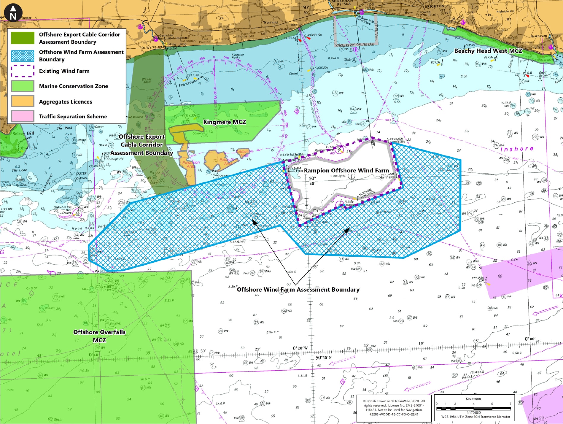
The English Channel is the busiest shipping lane in Europe, which is situated between the two pink areas on the AoS chart. The pink areas themselves show the Traffic Separation Scheme (TSS), which must be kept clear of permanent obstructions as it acts as a safety buffer between the English Channel shipping lane and the Inshore Traffic Zone.
To the west of the TSS is the shipping lane that takes traffic between the English Channel and Portsmouth & Southampton ports, and the Offshore Overfalls Marine Conservation Zone lies to the south of the western arm of the area being investigated, so there is no option to extend the Area of Search further to the south.
Following Scoping, two workshops were held which brought together technical engineering and environmental specialists. These considered feedback from stakeholders and the Scoping Opinion, in order to reduce the area of the Scoping Boundary to the PEIR Assessment Boundary.
As a result of concerns about shipping and navigation issues, the eastern edge of the Scoping Boundary was refined to increase the distance to the Dover Strait Traffic Separation Scheme, and the western edge was refined to provide more space between the array area and the Marine Conservation Zone containing Owers and Mixon rocks.
Concerns regarding visual impact have also been considered by reducing the Zone 6 area in the east, to reduce the impact from the Sussex Heritage Coast. In addition, this eastern area was reduced in order to ensure it was fully covered by existing digital aerial ornithological surveys.

One of the first requirements for a wind farm development is to establish where the power can be connected to the national grid network.
Rampion 2 could generate three times the amount of power as the operating Rampion wind farm, making it equivalent to the size of a large power station.
While the preference would be to connect the power nearer the coast, a project producing this level of power generation can’t connect to the distribution grid, which serves our homes and businesses. There isn’t the available capacity and if there were, it would require a number of offshore cables connecting into
various populated locations, each requiring a new substation.
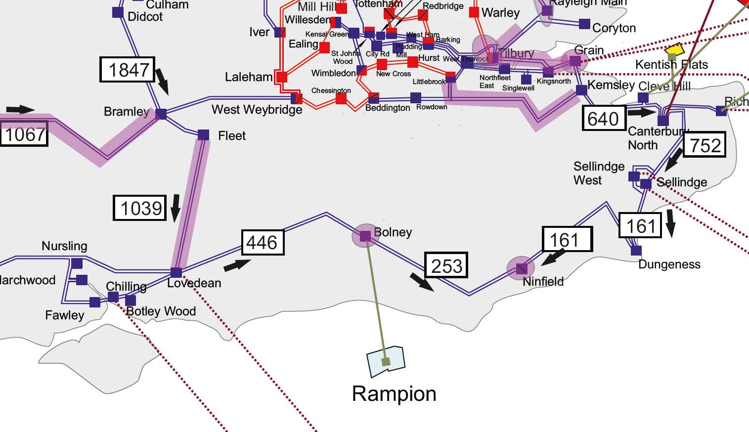
Rampion 2 must connect to the high voltage (400kV) transmission grid, what the Project Team sometimes call the, ‘electron motorway’, which is designed to take power from large generating plant.
The transmission system runs west to east inland from Hampshire, through Sussex to Kent and ultimately to London, to carry the power. Every so often along the network are ‘nodes’ where major generators can connect their power and where lower voltage distribution networks (like the equivalent of A and B roads) can tap into the power to feed the southeast region, one of the highest electricity demand centres in the country.
National Grid was commissioned to conduct a Feasibility Study for connection into their system and the Rampion 2 electrical engineers also investigated a number of alternative connection points at different ‘nodes’ along the transmission grid. Other options involved more lengthy and costly offshore export cables, which are 5-10 times the cost of onshore cables and would
render the project commercially unviable.
At the second closest connection node at Lovedean in Hampshire, some potential onshore cable routes were investigated but not only were they 10km longer, they would also require a significantly longer section through the South Downs National Park and were more environmentally challenging.
National Grid, who ultimately makes the decision on where we can connect to their system, determined the connection point at their Bolney Subsation in Twineham, Mid Sussex. This was based on technical criteria and Grid Code obligations to the regulator (Ofgem). The Rampion 2 agreement is for a connection in 2028/29.
Bolney is by far the closest connection point requiring the shortest onshore and offshore cable routes with the shortest route through the National Park and the least disturbance to local ecology, marine features and other sea users.
At the time of investment in 2015, there was no immediate prospect of future Crown Estate leasing rounds for this area. The Crown Estate first suggested a round for extension proposals in 2018.
The industry regulator requires every project to be designed and invested in an economic and efficient manner, to minimise cost to the end consumer, which prevents us from building speculative/spare capacity. The cables for the original Rampion project were therefore rated at a maximum capacity of 400MW.
The electricity generated feeds into the National Grid system and is therefore distributed to where there is demand. Given the power is connected in Sussex, it is likely that much of the electricity generated by Rampion 2 will be consumed across a broad area covering Sussex. It’s impossible to track electrons but the grid ensures the energy is not wasted, so on occasions when local demand is low and the wind farm is operating at peak, the power may be used further afield.
The ultimate objective is to connect the power from the wind farm to the transmission grid at Bolney using the shortest, least-impact cable route.
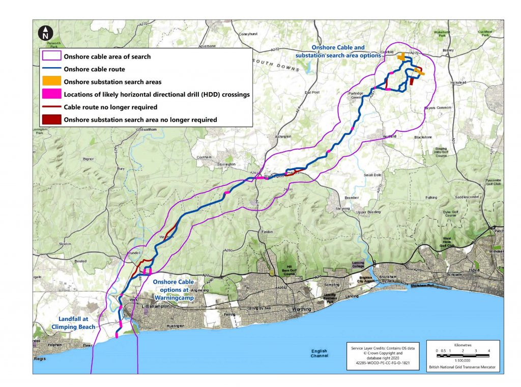
The first challenge is to identify where the cables can be brought ashore, known as ‘landfall’, where the offshore cables are joined to the onshore cables. Ideally, this location would be in the most direct path between the wind farm and Bolney. However, the Sussex coastline is a densely populated linear urban development, which severely restricts the number of potential landfall options.
While at first sight it may appear that there are one or two areas of open space along the coast e.g. Goring Gap, as the cables routed further north they would hit a dead end as they meet settlements which cannot be drilled under. The map in this following section illustrates the limited gaps within the dense coastal urban strip.
The open space that is closest to a direct line between the offshore PEIR boundary and Bolney, that also has the potential for a cable route to continue north, is Climping Beach just to the west of Littlehampton Harbour. To avoid disturbing the beach at Climping, this section of the route will be drilling under the beach to the agricultural land beyond.
Having identified the optimum landfall location, the cable route then takes the most direct and least-impact route between Climping and Bolney. The cable circuits will be buried underground for the entirety of the route, so the impacts will be temporary in nature during construction only and there will be no pylons.
Due to the east-west linear nature of the South Downs National Park, crossing it with the cable route will be unavoidable. The route is being designed to be as short as possible through the South Downs and construction methods will be introduced to ensure swift and successful reinstatement of the landscape.
There are a number of pinch points where the land is congested with other
constraints. The original landfall location at Brooklands Pleasure Park in Lancing, is highly congested with underground pipes and services, as well as cables from the original Rampion scheme. There is insufficient remaining space to cross
Teville Stream and drilling is not an option due to the location of an old landfill site.
Further north at Tottington Mount, the original cable route has utilised the available width on the crest of the hill, such that a parallel route would require
‘benching’ into the side of a hillside (such as used for roads/railways running across slopes), which is not an option due to visual and habitat sensitivities.
The Scoping Boundary of the onshore cable corridor from Climping to Bolney included options for sections of the route where there was insufficient information to choose the best route (at Climping, Warningcamp, Wepham, Norfolk Clump, Washington, Windmill Quarry, Henfield, Bolney Road / Kent Street, and around the substation areas of search). Following scoping, the number of options was reduced through a process that included stakeholder engagement, the first consultation, specialist workshops and additional environmental surveys.
Design refinement workshops were carried out to compare the potential alternatives to classify the following constraints for each option using a colour coding and rating system:
The ratings were used to compare the potential alternatives and a result, most options were removed to create the onshore cable route for public consultation. Options remain at Warningcamp and close to the substation areas of search, and will be refined further following the consultation and prior to DCO submission.
The area to site the permanent substation equipment will be no greater than 5.9 hectares (ha). However, a total area of 9ha is required to ensure there is space for access, compounds and laydown areas during construction, and also room for mitigation landscaping and planting to help screen the substation equipment.
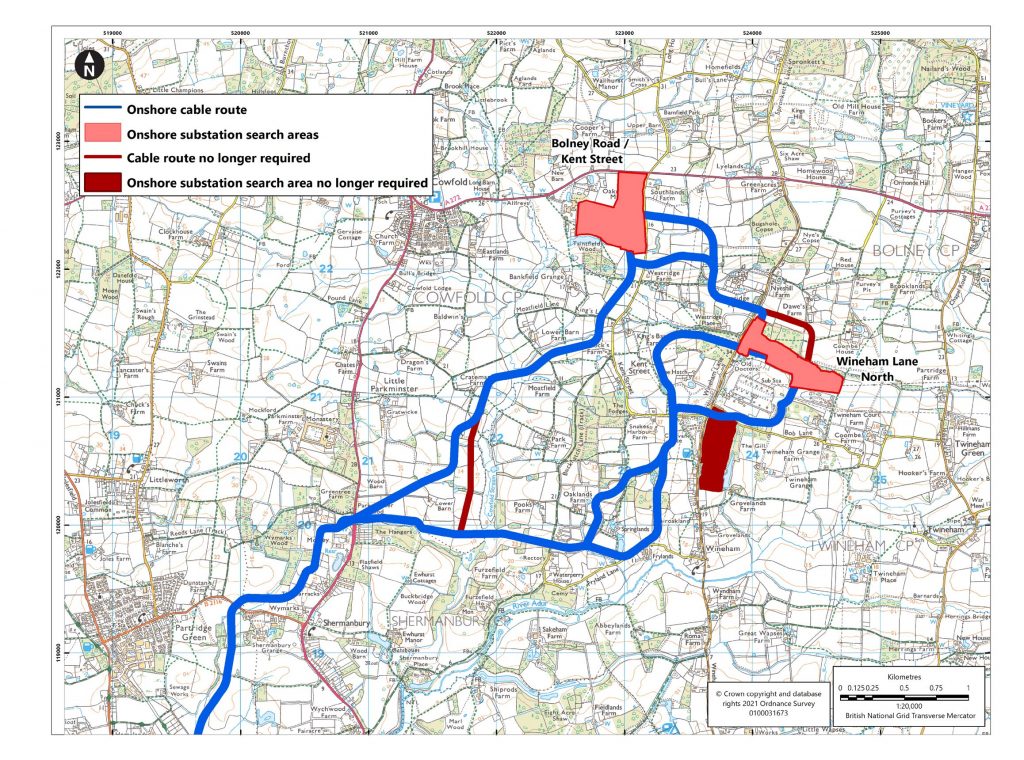
Seven substation search areas within 5km of the Bolney connection were initially investigated, to seek to identify the site of least impact. Four of these were discounted after Scoping and prior to the first consultation for a combination of reasons, such as:
The three remaining options that were taken to the first
consultation were:
Having listened to the feedback from local parish councils and residents, alongside the results of technical and environmental surveys, Wineham Lane South was discounted as it was found to have the most environmental constraints and local community concerns.
Both Bolney Road / Kent Street and Wineham Lane North substation search areas have been retained within the PEIR Assessment Boundary. Options for the cable route to connect to the substation have been included in the PEIR, as the final
cable route selection depends in part on the substation location.
For further information on the alternatives considered for the substation search areas and cable route options, please see Section 3.4 of the PEIR Alternatives Chapter.
Design evolution will continue within the PEIR Assessment Boundary and will be refined further, prior to DCO submission. The final design will take into account full consideration of additional data obtained through further site-specific surveys, desk-based reviews and feedback from the public consultation.
Offshore, some decisions are able to be finalised prior to DCO application. However, the precise locations of turbines, offshore substations and associated offshore cables will all require subsea site investigations, which involve 50metre deep borehole surveys to ascertain the ground conditions. These investigations are very costly and as such, take place once consent has been awarded and there is certainty that the project will go ahead.
Onshore, consultation feedback and further information on constraints at each of the two substation options will be gathered, to inform the selection of the final substation location in advance of the DCO application. The final layout, landscaping and mitigation planting will be discussed with the local community as the project progresses.
| Decision Outstanding | When decision will be made |
|---|---|
|
OFFSHORE |
|
|
Offshore wind farm area |
DCO application, early 2022 |
|
Maximum turbine height and numbers |
DCO application, early 2022 |
|
Precise turbine height, numbers and
locations |
Following results of borehole site
investigations, approx. 2023-24 |
|
Precise number and location of (max 3)
offshore substations |
Following results of borehole site
investigations, approx. 2023-24 |
|
Offshore inter-array and export cable
routes |
Following final layout of wind farm after
site investigations |
|
ONSHORE |
|
|
Warningcamp final cable route
selection |
DCO application, early 2022 |
|
Final Horizontal Directional Drill
sections |
DCO application, early 2022 |
|
Onshore substation site selection |
DCO application, early 2022 |
|
Onshore substation layout |
Following more detailed investigations
and engagement with local community,
approx. 2024 |